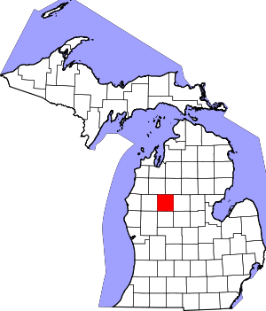
Osceola County | |
|---|---|
 Osceola County Courthouse | |
 Location within the U.S. state of Michigan | |
 Michigan's location within the U.S. | |
| Coordinates: 43°59′N 85°20′W / 43.98°N 85.33°W | |
| Country | |
| State | |
| Founded | April 1, 1840 (created) 1869 (organized)[1] |
| Named for | Osceola |
| Seat | Reed City |
| Largest city | Reed City |
| Area | |
| • Total | 573 sq mi (1,480 km2) |
| • Land | 566.39 sq mi (1,466.9 km2) |
| • Water | 6.7 sq mi (17 km2) 1.2% |
| Population (2020) | |
| • Total | 22,891 |
| • Density | 41.4/sq mi (16.0/km2) |
| Time zone | UTC−5 (Eastern) |
| • Summer (DST) | UTC−4 (EDT) |
| Congressional district | 2nd |
| Website | www |
Osceola County (/ˌɒsiˈoʊlə/ OSS-ee-OH-lə) is a county in the U.S. state of Michigan. As of the 2020 United States Census, the population was 22,891.[2] The county seat is Reed City.[3]
- ^ "Bibliography on Osceola County". Clarke Historical Library, Central Michigan University. Retrieved January 29, 2013.
- ^ "State & County QuickFacts". US Census Bureau. Retrieved September 15, 2021.
- ^ "Find a County". National Association of Counties. Retrieved June 7, 2011.
