| Osney Lock | |
|---|---|
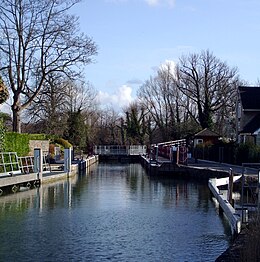
 Osney Lock, looking upstream from the north | |
 | |
| Waterway | River Thames |
| County | Oxfordshire |
| Maintained by | Environment Agency |
| Operation | Hydraulic |
| First built | 1790 |
| Latest built | 1905 |
| Length | 34.64 m (113 ft 8 in) [1] |
| Width | 5.25 m (17 ft 3 in)[1] |
| Fall | 1.89 m (6 ft 2 in)[1] |
| Above sea level | 185' |
| Distance to Teddington Lock | 93 miles |
Osney Lock | ||||||||||||||||||||||||||||||||||||||||||||||||||||||||||||||||||||||||||||||||||||||||||||||||||||||||||||||||||||||||||||||||||||||||||||||||||||||||||||||||||||||||||||||||||||||||||||||||||||||||||||||||||||||||||||||||||||||||||||||
|---|---|---|---|---|---|---|---|---|---|---|---|---|---|---|---|---|---|---|---|---|---|---|---|---|---|---|---|---|---|---|---|---|---|---|---|---|---|---|---|---|---|---|---|---|---|---|---|---|---|---|---|---|---|---|---|---|---|---|---|---|---|---|---|---|---|---|---|---|---|---|---|---|---|---|---|---|---|---|---|---|---|---|---|---|---|---|---|---|---|---|---|---|---|---|---|---|---|---|---|---|---|---|---|---|---|---|---|---|---|---|---|---|---|---|---|---|---|---|---|---|---|---|---|---|---|---|---|---|---|---|---|---|---|---|---|---|---|---|---|---|---|---|---|---|---|---|---|---|---|---|---|---|---|---|---|---|---|---|---|---|---|---|---|---|---|---|---|---|---|---|---|---|---|---|---|---|---|---|---|---|---|---|---|---|---|---|---|---|---|---|---|---|---|---|---|---|---|---|---|---|---|---|---|---|---|---|---|---|---|---|---|---|---|---|---|---|---|---|---|---|---|---|---|---|---|---|---|---|---|---|---|---|---|---|---|---|---|---|
| ||||||||||||||||||||||||||||||||||||||||||||||||||||||||||||||||||||||||||||||||||||||||||||||||||||||||||||||||||||||||||||||||||||||||||||||||||||||||||||||||||||||||||||||||||||||||||||||||||||||||||||||||||||||||||||||||||||||||||||||
Osney Lock is a lock on the River Thames in Oxford, England, where the village or island of Osney is next to the river.
The first lock was built of stone by Daniel Harris for the Thames Navigation Commission in 1790.[2]
Across the weir pool is a large Environment Agency complex which monitors the River Thames, while a small office building exists on the front lawn opposite from the lock house. The weir is upstream of the lock alongside the navigation channel in two parts and feeds the Osney pool. The Osney Lock Hydro hydro-electric plant occupies a building beside the weir.
To the south and southwest are Osney Mill Marina and Osney Cemetery. Oxford railway station on the Botley Road is close by to the northwest.
- ^ a b c "Environment Agency Dimensions of locks on the River Thames". web page. Environmental Agency. 8 November 2012. Retrieved 17 November 2012. Dimensions given in metres
- ^ Davies & Robinson, 2003, pages 76-77