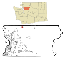
Oso, Washington | |
|---|---|
 Location of Oso, Washington | |
| Coordinates: 48°16′20″N 121°55′9″W / 48.27222°N 121.91917°W | |
| Country | United States |
| State | Washington |
| County | Snohomish |
| Area | |
• Total | 3.7 sq mi (9.6 km2) |
| • Land | 3.6 sq mi (9.4 km2) |
| • Water | 0.1 sq mi (0.2 km2) |
| Elevation | 207 ft (63 m) |
| Population (2020) | |
• Total | 172 |
| • Density | 46/sq mi (18/km2) |
| Time zone | UTC-8 (Pacific (PST)) |
| • Summer (DST) | UTC-7 (PDT) |
| ZIP code | 98223 |
| Area code | 360 |
| FIPS code | 53-52110[1] |
| GNIS feature ID | 1524091[2] |
Oso is a census-designated place (CDP) in Snohomish County, Washington,[3][4] United States. It is located to the west of Darrington, south of the North Fork of the Stillaguamish River and approximately 50 air miles (80 km) from Seattle. The population of Oso was 172 at the 2020 census.[5] The area was the site of a large landslide in March 2014 that killed 43 people, the deadliest incident of its kind in U.S. history.
- ^ "U.S. Census website". United States Census Bureau. Retrieved January 31, 2008.
- ^ "US Board on Geographic Names". United States Geological Survey. October 25, 2007. Retrieved January 31, 2008.
- ^ "Oso Census Designated Place: United States , geographic coordinates, administrative division, map". Geographical Names. Retrieved March 28, 2014.
- ^ "Oso: United States , geographic coordinates, administrative division, map". Geographical Names. Retrieved March 28, 2014.
- ^ "Census Bureau profile: Oso, Washington". United States Census Bureau. May 2023. Retrieved May 8, 2024.