Oswegatchie, New York | |
|---|---|
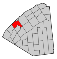
 Map highlighting Oswegatchie's location within St. Lawrence County. | |
| Coordinates: 44°37′32″N 75°27′55″W / 44.62556°N 75.46528°W | |
| Country | United States |
| State | New York |
| County | St. Lawrence |
| Area | |
| • Total | 71.20 sq mi (184.41 km2) |
| • Land | 65.50 sq mi (169.64 km2) |
| • Water | 5.71 sq mi (14.77 km2) |
| Elevation | 282 ft (86 m) |
| Population (2010) | |
| • Total | 4,397 |
| • Estimate (2016)[2] | 4,337 |
| • Density | 66.22/sq mi (25.57/km2) |
| Time zone | UTC-5 (Eastern (EST)) |
| • Summer (DST) | UTC-4 (EDT) |
| FIPS code | 36-55563 |
| GNIS feature ID | 0979324 |
Oswegatchie is a town in St. Lawrence County, New York, United States. The population was 4,397 at the 2010 census. The name reportedly means "Black Water". It is on the northern border of the county and is adjacent to the city of Ogdensburg.[3]
- ^ "2016 U.S. Gazetteer Files". United States Census Bureau. Retrieved July 5, 2017.
- ^ Cite error: The named reference
USCensusEst2016was invoked but never defined (see the help page). - ^ "Explore Census Data". data.census.gov. Retrieved April 1, 2024.
