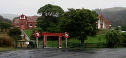
Otakou
Ōtākou (Māori) | |
|---|---|
 Ōtākou Marae | |
 | |
| Coordinates: 45°48′15″S 170°42′00″E / 45.80417°S 170.70000°E | |
| Country | New Zealand |
| Region | Otago |
| Territorial authority | Dunedin |
| Community board | Otago Peninsula Community Board[1][2] |
| Electorates |
|
| Government | |
| • Territorial authority | Dunedin City Council |
| • Regional council | Otago Regional Council |
| • Mayor of Dunedin | Jules Radich |
| • Dunedin MP | Rachel Brooking |
| • Te Tai Tonga MP | Tākuta Ferris |
| Area | |
| • Total | 5.65 km2 (2.18 sq mi) |
| Population (June 2024)[4] | |
| • Total | 210 |
| • Density | 37/km2 (96/sq mi) |
| Time zone | UTC+12 (NZST) |
| • Summer (DST) | UTC+13 (NZDT) |
| Local iwi | Ngāi Tahu |
Otakou (Māori: Ōtākou [ɔːˈtaːkɔʉ]) is a settlement within the boundaries of the city of Dunedin, New Zealand. It is located 25 kilometres from the city centre at the eastern end of Otago Peninsula, close to the entrance of Otago Harbour.[5][6][7] Though a small fishing village, Otakou is important in the history of Otago for several reasons. The settlement is the modern centre and traditional home of the Ōtākou rūnanga (assembly) of Ngāi Tahu. In 1946 Otakou Fisheries was founded in the township; this was later to become a major part of the Otago fishing industry.[8][9]
- ^ "Otago Peninsula Community Board | Community Plan 2019 – 2020" (PDF). dunedin.govt.nz. Dunedin City Council. Retrieved 2 June 2022.
- ^ "2016 Otago Peninsula Community Board Boundary" (PDF). dunedin.govt.nz. Dunedin City Council. Retrieved 2 June 2022.
- ^ Cite error: The named reference
Areawas invoked but never defined (see the help page). - ^ "Aotearoa Data Explorer". Statistics New Zealand. Retrieved 26 October 2024.
- ^ Dann, C; Peat, N (1989). Dunedin, North and South Otago. Wellington, NZ: GP Books. ISBN 0-477-01438-0.
- ^ Entwisle, Peter (1998). Behold the Moon: the European Occupation of the Dunedin District 1770-1848. Dunedin, NZ: Port Daniel Press. ISBN 0-473-05591-0.
- ^ Goodall, M; Griffiths, G (1980). Māori Dunedin. Dunedin, NZ: Otago Heritage Books.
- ^ Ellison, Craig. "Ellison, Raniera". Dictionary of New Zealand Biography. New Zealand Ministry for Culture and Heritage Te Manatu Taonga. Retrieved 26 November 2018.
- ^ "Ngai Tahu plays the long game". Otago Daily Times Online News. 6 November 2013. Retrieved 26 November 2018.