| Otava | |
|---|---|
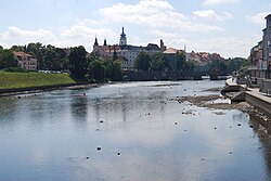
 The Otava in Písek | |
 | |
| Location | |
| Countries | Czech Republic |
| Regions | |
| Physical characteristics | |
| Source | Vydra |
| • location | Modrava, Bohemian Forest |
| • elevation | 975 m (3,199 ft) |
| Mouth | |
• location | Vltava |
• coordinates | 49°1′30″N 13°29′47″E / 49.02500°N 13.49639°E |
• elevation | 348 m (1,142 ft) |
| Length | 134.8 km (83.8 mi) |
| Basin size | 3,826.9 km2 (1,477.6 sq mi) |
| Discharge | |
| • average | 26.0 m3/s (920 cu ft/s) near estuary |
| Basin features | |
| Progression | Vltava→ Elbe→ North Sea |
The Otava (German: Wottawa) is a river in the Czech Republic, a left tributary of the Vltava River. It flows through the Plzeň and South Bohemian regions. It is formed by the confluence of the Vydra and Křemelná rivers. Together with the Vydra, which is its main source, the Otava is 134.8 km (83.8 mi) long, making it the 13th longest river in the country. Without the Vydra, it is 111.7 km (69.4 mi) long.