Otsego County | |
|---|---|
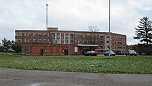
 Otsego County Building in Gaylord | |
 Location within the U.S. state of Michigan | |
 Michigan's location within the U.S. | |
| Coordinates: 45°01′N 84°37′W / 45.02°N 84.61°W | |
| Country | |
| State | |
| Founded | 1840 (created) 1875 (organized)[1] |
| Seat | Gaylord |
| Largest city | Gaylord |
| Area | |
• Total | 526 sq mi (1,360 km2) |
| • Land | 514 sq mi (1,330 km2) |
| • Water | 11 sq mi (30 km2) 2.1% |
| Population (2020) | |
• Total | 25,091 |
| • Density | 47/sq mi (18/km2) |
| Time zone | UTC−5 (Eastern) |
| • Summer (DST) | UTC−4 (EDT) |
| Congressional district | 1st |
| Website | otsegocountymi |

Otsego County (/ɒtˈsiːɡoʊ/ ot-SEE-goh), formerly known as Okkuddo County, is a county located in the U.S. state of Michigan. As of the 2020 census, the population was 25,091.[2] The county seat is Gaylord.[3] The county was founded in 1840 and organized in 1875.[1]
- ^ a b "Bibliography on Otsego County". Clarke Historical Library, Central Michigan University. Retrieved January 29, 2013.
- ^ "State & County QuickFacts". United States Census Bureau. Retrieved September 15, 2021.
- ^ "Find a County". National Association of Counties. Retrieved June 7, 2011.