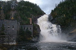
| Ouiatchouan River | |
|---|---|
 | |
| Location | |
| Country | Canada |
| Province | Quebec |
| Region | Saguenay–Lac-Saint-Jean |
| MRC | Le Domaine-du-Roy Regional County Municipality |
| Physical characteristics | |
| Source | Lac des Commissaires |
| • location | Lac-Bouchette |
| • coordinates | 48°12′12″N 72°14′32″W / 48.20333°N 72.24222°W |
| • elevation | 331 m (1,086 ft) |
| Mouth | Lac Saint-Jean |
• location | Chambord |
• coordinates | 48°26′53″N 72°09′33″W / 48.44806°N 72.15917°W |
• elevation | 101 m (331 ft) |
| Length | 35 km (22 mi) |
| Basin features | |
| Progression | Lac Saint-Jean, Saguenay River |
| Tributaries | |
| • left | (upstream) Ouellet River, 3 lakes outlet, 5 lakes outlet, Petite rivière Ballantyne, Sergerie River, Noire River. |
| • right | (upstream) ruisseau non-identifié, Petite rivière de la Savane, décharge du Lac des Bouleaux, Le Faux Canal. |
La rivière Ouiatchouan (formerly Ouiatchouane[1]) is a tributary of lac Saint-Jean, flowing in the municipalities of Lac-Bouchette and Chambord, in the Le Domaine-du-Roy Regional County Municipality, in the administrative region of Saguenay–Lac-Saint-Jean, from province of Quebec, to Canada.
Apart from the lower zone, forestry is the main economic activity in this valley.[2]
The surface of the Ouiatchouan River is usually frozen from the beginning of December to the end of March, except the rapids areas; however, safe circulation on the ice is generally from mid-December to mid-March.
- ^ Commission de toponymie du Québec, /fiche.aspx?no_seq=148370 Ouiatchouan River [online] (Page consulted on January 9, 2013)
- ^ OpenStreetMap – Accessed July 13, 2020