| Outback Communities Authority South Australia | |||||||||||||||
|---|---|---|---|---|---|---|---|---|---|---|---|---|---|---|---|
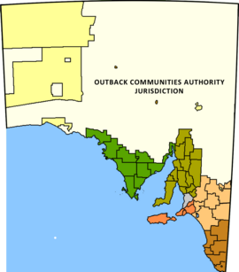
 The extent of the Pastoral Unincorporated Area of South Australia (shown in white) | |||||||||||||||
| Population | 3,524 (2016 census)[1] | ||||||||||||||
| • Density | 0.0056444/km2 (0.0146188/sq mi) | ||||||||||||||
| Established | 2009 | ||||||||||||||
| Area | 624,339.0 km2 (241,058.6 sq mi) | ||||||||||||||
| Mayor | Cecilia Woolford[2] | ||||||||||||||
| Council seat | Port Augusta Andamooka | ||||||||||||||
| Region | Far North[3] Eyre and Western[4] | ||||||||||||||
| State electorate(s) | Giles, Stuart, Flinders[5][6][7] | ||||||||||||||
| Federal division(s) | Grey[8] | ||||||||||||||
 | |||||||||||||||
The Outback Communities Authority (OCA) is a statutory authority in South Australia (SA) created under the Outback Communities (Administration and Management) Act 2009.[9] It has been established to "manage the provision of public services and facilities to outback communities" which are widely dispersed across the Pastoral Unincorporated Area which covers almost 60% of South Australia's land area.[10] The authority has its seat at both Port Augusta which is located outside the unincorporated area and at Andamooka. The authority serves an area of 624,339 square kilometres (241,059 square miles),[11] slightly smaller than France. The area has a population of 3,750, of whom 639 are Indigenous Australians, and includes several large pastoral leases and mining operations.[12]
The authority's area of responsibility does not include Aboriginal Local Government Areas, the largest of which are Anangu Pitjantjatjara Yankunytjatjara in the northwest of SA and Maralinga Tjarutja in the west of SA.
- ^ Australian Bureau of Statistics (27 June 2017). "Unincorporated SA". 2016 Census QuickStats. Retrieved 10 April 2018.
- ^ "OCA members". Government of South Australia. Retrieved 12 October 2014.
- ^ "Far North SA Government Region" (PDF). Department of Planning, Transport and Infrastructure. Retrieved 10 October 2014.
- ^ "Eyre Western SA Government region" (PDF). The Government of South Australia. Retrieved 10 October 2014.
- ^ "Giles, 2014 State election boundaries". ELECTORAL COMMISSION SA. Retrieved 17 October 2014.
- ^ "Flinders, 2014 State election boundaries". ELECTORAL COMMISSION SA. Retrieved 17 October 2014.
- ^ "Stuart, 2014 State election boundaries". ELECTORAL COMMISSION SA. Retrieved 17 October 2014.
- ^ "Federal electoral division of Grey, boundary gazetted 16 December 2011" (PDF). Australian Electoral Commission. Retrieved 20 August 2015.
- ^ "Outback Communities (Administration and Management) Act 2009". Attorney-General's Department, Government of South Australia. Retrieved 10 October 2014.
- ^ OCA, 2013, page 3
- ^ http://www.abs.gov.au/AUSSTATS/[email protected]/Latestproducts/LGA19399Environment/Energy12002-2006?opendocument&tabname=Summary&prodno=LGA19399&issue=2002-2006[permanent dead link]
- ^ Census 2006