| Outer Ring Road, Hyderabad | |
|---|---|
| Nehru Outer Ring Road | |
Hyderabad Outer Ring Road in red | |
 | |
| Route information | |
| Maintained by Greater Hyderabad Municipal Corporation, Hyderabad Metropolitan Development Authority | |
| Length | 158 km (98 mi) |
| Existed | 2005–present |
| Restrictions | Two and three-wheeler vehicles are not allowed |
| Major junctions | |
| North end | Gachibowli |
| South end | Narsingi |
| Location | |
| Country | India |
| State | Telangana |
| Highway system | |
| State Highways in Telangana | |
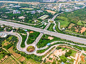
The Hyderabad Outer Ring Road, officially known as Nehru Outer Ring Road and abbreviated as, H.O.R.R., is a 158-kilometre (98 mi), eight-lane ring road expressway encircling Hyderabad, capital of the Indian state of Telangana. The expressway was designed for speeds up to 100 kilometres per hour (62 mph), later increased to 120 kilometres per hour (75 mph).[1] A large part, 124 kilometres (77 mi) (covering urban nodes viz., Hi- Tech city, Nanakramguda Financial District, Rajiv Gandhi International Airport, IKP Knowledge park, Hardware Park, Telangana State Police Academy, Singapore Financial District, and Games village) of the 158 kilometres (98 mi) was opened by December 2012.[2]
On 3 January 2006, Prime Minister Dr. Manmohan Singh laid the foundation stone for the proposed Outer Ring Road (Phase I) near Shamshabad on the outskirts of Hyderabad. The project was part of broader vision to develop Hyderabad into a world-class city and a hub for information technology and other industries.
It gives easy connectivity between NH 44, NH 65, NH 161, NH 765 and NH 163 from Hyderabad to Vijayawada and Warangal as well as state highways leading to Vikarabad Nagarjuna Sagar and Karimnagar /Mancherial.[3] The Hyderabad Outer Ring Road also helps reduce the travel time from Rajiv Gandhi International Airport to cities like Nizamabad and Adilabad as it connects to NH44. The expressway is fenced and 33 radial roads connect it with the Inner Ring Road,[4] and the upcoming Regional Ring Road.
- ^ "Speed limit on ORR raised to 120 kmph, citizens rejoice". The Hindu. 27 June 2023. ISSN 0971-751X. Retrieved 10 July 2023.
- ^ Another Outer Ring Road stretch to be opened today. The Times of India]. (3 December 2012).
- ^ Cities. Deccan Chronicle. Retrieved on 6 December 2013.
- ^ HMDA seeks approval to work on 16 radial roads. The Hindu (3 December 2012). Retrieved on 6 December 2013.
