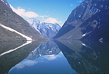
Overdeepening is a characteristic of basins and valleys eroded by glaciers. An overdeepened valley profile is often eroded to depths which are hundreds of metres below the lowest continuous surface line (the thalweg) along a valley or watercourse. This phenomenon is observed under modern day glaciers, in salt-water fjords and fresh-water lakes remaining after glaciers melt, as well as in tunnel valleys which are partially or totally filled with sediment. When the channel produced by a glacier is filled with debris, the subsurface geomorphic structure is found to be erosionally cut into bedrock and subsequently filled by sediments. These overdeepened cuts into bedrock structures can reach a depth of several hundred metres below the valley floor.[1]
Overdeepened fjords and lakes have significant economic value as harbours and fisheries. Overdeepened basins and valleys filled with sediment (termed tunnel valleys) are of particular interest to engineers, petroleum geologists, and hydrologists; engineers apply the information for developing foundations and tunnel construction, petroleum geologists use tunnel valley locations to identify potential oil fields, while hydrologists apply this knowledge for groundwater resource management.[1]
- ^ a b Fiebig, Markus; Frank Preusser; Kurt Decker; Christian Schlüchter (2010). "Preface: special section of papers dealing with overdeepened basins and valleys in the alpine realm". Swiss Journal of Geosciences. 103 (3): 327–328. doi:10.1007/s00015-010-0040-2.