This article needs additional citations for verification. (January 2013) |
Province of Overijssel
| |
|---|---|
|
| |
| Anthem: "Aan de rand van Hollands gouwen" "On the edge of Holland's provinces" | |
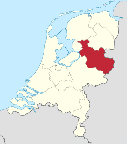
 Location of Overijssel in the Netherlands | |
 Topography map of Overijssel | |
| Country | Netherlands |
| Capital | Zwolle |
| Largest city | Enschede |
| Government | |
| • King's Commissioner | Andries Heidema (CU) |
| • Council | Provincial Council of Overijssel |
| Area (2023)[1] | |
• Total | 3,421 km2 (1,321 sq mi) |
| • Land | 3,317 km2 (1,281 sq mi) |
| • Water | 104 km2 (40 sq mi) |
| • Rank | 5th |
| Population (1 January 2023)[2] | |
• Total | 1,184,333 |
| • Rank | 6th |
| • Density | 357/km2 (920/sq mi) |
| • Rank | 7th |
| GDP | |
| • Total | €47.980 billion |
| • Per capita | €41,600 |
| ISO 3166 code | NL-OV |
| Religion (2006) | Protestant 29% Catholic 26% Muslim 2% Others 6% Non-religious 37% |
| HDI (2021) | 0.927[4] very high · 7th |
| Website | www.overijssel.nl |
Overijssel (Dutch pronunciation: [ˌoːvərˈɛisəl] ; Dutch Low Saxon: Oaveriessel [ˌɒːvərˈiːsl̩]; German: Oberyssel; lit. 'Outer IJssel') is a province of the Netherlands located in the eastern part of the country. The province's name comes from the perspective of the Episcopal principality of Utrecht, which held the territory until 1528. The capital city of Overijssel is Zwolle (pop. 132,441[5]) and the largest city is Enschede (pop. 161,235). The province had a population of about 1,184,000 as of January 2023. The land mostly consists of grasslands and some forests (including Sallandse Heuvelrug National Park); it also borders a small part of the IJsselmeer to the west.
- ^ Statistieken provincie Overijssel - Gegevens over meer dan 100 onderwerpen!, AlleCijfers.nl
- ^ "CBS Statline".
- ^ "EU regions by GDP, Eurostat". Retrieved 18 September 2023.
- ^ "Sub-national HDI – Area Database – Global Data Lab". hdi.globaldatalab.org. Retrieved 2018-09-13.
- ^ "CBS Statline".

