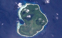
 Landsat picture of the island. | |
 Owaraha (Santa Ana) is located off the eastern end of Makira Island | |
| Geography | |
|---|---|
| Location | South Pacific Ocean |
| Coordinates | 10°49′42″S 162°27′49″E / 10.82833°S 162.46361°E |
| Archipelago | Solomon Islands (archipelago) |
| Area | 15.7 km2 (6.1 sq mi) |
| Highest elevation | 143 m (469 ft) |
| Highest point | Farina |
| Administration | |
| Province | Makira-Ulawa Province |
| Demographics | |
| Population | 1547 (2009) |
Owaraha or Owa Raha (also known as Santa Ana) is an island in Makira-Ulawa Province, Solomon Islands.
