Owenton, Kentucky | |
|---|---|
 Downtown Owenton | |
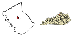
 Location of Owenton in Owen County, Kentucky. | |
| Coordinates: 38°32′19″N 84°50′27″W / 38.53861°N 84.84083°W | |
| Country | United States |
| State | Kentucky |
| County | Owen |
| Incorporated | 1828[1] |
| Reincorporated | 1849[1] |
| Named for | Its County |
| Area | |
| • Total | 1.93 sq mi (5.01 km2) |
| • Land | 1.90 sq mi (4.92 km2) |
| • Water | 0.03 sq mi (0.08 km2) |
| Elevation | 958 ft (292 m) |
| Population (2020) | |
| • Total | 1,682 |
| • Estimate (2022)[4] | 1,671 |
| • Density | 884.80/sq mi (341.63/km2) |
| Time zone | UTC-5 (Eastern (EST)) |
| • Summer (DST) | UTC-4 (EDT) |
| ZIP code | 40359 |
| Area code | 502 |
| FIPS code | 21-58692 |
| GNIS feature ID | 2404449[3] |
Owenton is a home rule-class city[5] in and the county seat of Owen County, Kentucky, United States.[6] The population was 1,327 at the 2010 census. It is located at the junction of U.S. Route 127 and Kentucky Route 22, about halfway between Louisville and Cincinnati.
- ^ a b Commonwealth of Kentucky. Office of the Secretary of State. Land Office. "Owenton, Kentucky". Accessed 18 September 2013.
- ^ "2020 U.S. Gazetteer Files". United States Census Bureau. Retrieved March 18, 2022.
- ^ a b U.S. Geological Survey Geographic Names Information System: Owenton, Kentucky
- ^ "Annual Estimates of the Resident Population for Incorporated Places in Kentucky: April 1, 2020 to July 1, 2022". United States Census Bureau. Retrieved May 26, 2023.
- ^ "Summary and Reference Guide to House Bill 331 City Classification Reform" (PDF). Kentucky League of Cities. Retrieved December 30, 2014.
- ^ "Find a County". National Association of Counties. Retrieved June 7, 2011.