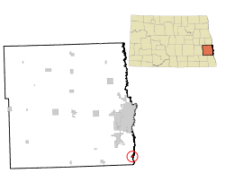
Oxbow, North Dakota | |
|---|---|
 Location of Oxbow, North Dakota | |
| Coordinates: 46°39′46″N 96°48′39″W / 46.66278°N 96.81083°W | |
| Country | United States |
| State | North Dakota |
| County | Cass |
| Founded | October 25, 1988 |
| Government | |
| • Mayor | Jim Nyhof |
| Area | |
• Total | 1.53 sq mi (3.97 km2) |
| • Land | 1.53 sq mi (3.97 km2) |
| • Water | 0.00 sq mi (0.00 km2) |
| Elevation | 915 ft (279 m) |
| Population | |
• Total | 381 |
• Estimate (2023)[4] | 371 |
| • Density | 248.69/sq mi (96.00/km2) |
| Time zone | UTC-6 (Central (CST)) |
| • Summer (DST) | UTC-5 (CDT) |
| ZIP code | 58047 |
| Area code | 701 |
| FIPS code | 38-60480 |
| GNIS feature ID | 1033709[2] |
| Website | oxbownd.com |
Oxbow is a city in Cass County, North Dakota, United States. The population was 381 at the 2020 census.[3] It is an upscale bedroom community located 15 miles (24 km) south of Fargo. It was incorporated as a city October 25, 1988.
- ^ "ArcGIS REST Services Directory". United States Census Bureau. Retrieved September 20, 2022.
- ^ a b U.S. Geological Survey Geographic Names Information System: Oxbow, North Dakota
- ^ a b "Explore Census Data". United States Census Bureau. Retrieved October 13, 2023.
- ^ Cite error: The named reference
USCensusEst2022was invoked but never defined (see the help page).