This article is written like a travel guide. (June 2020) |
| Pa Sak Cholasit Dam | |
|---|---|
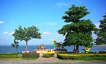
 Pa Sak Cholasit Dam with the Dong Phaya Yen Range in the background | |
| Country | Thailand |
| Location | Phatthana Nikhom, Lopburi with Wang Muang, Saraburi |
| Coordinates | 14°51′41″N 101°03′58″E / 14.86139°N 101.06611°E |
| Status | Operational |
| Construction began | 1991 |
| Opening date | 1999 |
| Dam and spillways | |
| Type of dam | Embankment, earth-fill |
| Impounds | Pa Sak River |
| Height | 36.5 m (120 ft) |
| Length | 4,860 m (15,940 ft) |
| Reservoir | |
| Total capacity | 960,000,000 m3 (778,285 acre⋅ft) |
| Power Station | |
| Installed capacity | 6.7 MW |
The Pa Sak Jolasid Dam or Pa Sak Cholasit Dam (Thai: เขื่อนป่าสักชลสิทธิ์, RTGS: Khuean Pa Sak Chonlasit pronounced [kʰɯ̀a̯n pàː sàk t͡ɕʰōn.lā.sìt]) impounds the Pa Sak River at Ban Kaeng Suea Ten, Tambon Nong Bua, Phatthana Nikhom District, Lopburi Province, and Ban Kham Phran, Tambon Kham Phran, Wang Muang District, Saraburi Province, Thailand. It is the biggest reservoir in central Thailand.[1]
The 4,860-meter (15,940 ft) wide and 36.5-meter (120 ft) high dam is earth-filled with an impervious core. The storage capacity is 785 million m3 of water at normal water level, with a maximum capacity of 960 million m3. The dam also supplies about 6.7 MW of hydro-electric power.
- ^ "Pa Sak Jolasid Dam". TAT. Archived from the original on 5 November 2015. Retrieved 8 August 2015.
