This article needs additional citations for verification. (October 2007) |

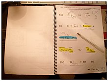
In rallying, pacenotes are a commonly used method of accurately describing a rallying route to be driven in extreme detail. As well as dictating the general route to be taken, in terms of turnings, junctions, etc., all notable features of the route which might affect the way it is driven at speed are included. These details include the distance between each feature, the degree and severity of bends, adverse camber, crests and hill jumpings, surface type and conditions, potholes, special instructions to the driver, etc.
In order that the sheer quantity of detail is useful to a rally team, pacenotes are written in a tight shorthand which is read out loud by the navigator (usually called "co-driver") to the driver en route.[1] A number of systems have been devised, and there is no one "standard" for pacenotes, but in practice a number of typical de facto standards are usually used. Other variations include the preferred language of the team, metric or imperial measurements, etc. Pacenotes for a typical world-class rally stage might run to many pages, and the road book for the event might be several thick bound volumes.
On some events, the organisers provide an official set of pacenotes, and often the rules ban reconnaissance (recce), meaning these notes are the only ones to be used. Other events permit crews to use any notes, either supplied to them by others or those they have compiled themselves. Compilation of notes requires access to the course ahead of the event, which is not always possible.