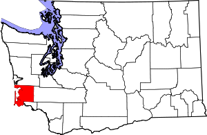
Pacific County | |
|---|---|
 Pacific County Courthouse, South Bend | |
 Location within the U.S. state of Washington | |
 Washington's location within the U.S. | |
| Coordinates: 46°34′N 123°47′W / 46.56°N 123.78°W | |
| Country | |
| State | |
| Founded | February 4, 1851 |
| Named for | Pacific Ocean |
| Seat | South Bend |
| Largest city | Raymond |
| Area | |
| • Total | 1,223 sq mi (3,170 km2) |
| • Land | 933 sq mi (2,420 km2) |
| • Water | 291 sq mi (750 km2) 24% |
| Population (2020) | |
| • Total | 23,365 |
| • Estimate (2023) | 24,200 |
| • Density | 19/sq mi (7/km2) |
| Time zone | UTC−8 (Pacific) |
| • Summer (DST) | UTC−7 (PDT) |
| Congressional district | 3rd |
| Website | www |
Pacific County is a county in the U.S. state of Washington. As of the 2020 census, the population was 23,365.[1] Its county seat is South Bend,[2] and its largest city is Raymond. The county was formed by the government of Oregon Territory in February 1851[3] and is named for the Pacific Ocean.
Pacific County is centered on Willapa Bay, a region that provides twenty-five percent of the United States oyster harvest,[4] although forestry, fishing, and tourism are also significant elements of the county's economy.
- ^ "State & County QuickFacts". United States Census Bureau. Retrieved November 9, 2024.
- ^ "Find a County". National Association of Counties. Retrieved June 7, 2011.
- ^ "Milestones for Washington State History — Part 2: 1851 to 1900". HistoryLink.org. March 6, 2003.
- ^ Chinook Observer, The Willapa Bay Oyster Industry: Shellfish is still No. 1 [1] Archived July 20, 2018, at the Wayback Machine