| Paddys | |
|---|---|
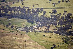
 Paddys River viewed from Gibraltar Peak | |
| Location | |
| Country | Australia |
| Territory | Australian Capital Territory |
| Region | South Eastern Highlands (IBRA), Capital Country |
| Physical characteristics | |
| Source confluence | Blue Gum Creek and Punchbowl Creek |
| • location | Castle Hill in Tidbinbilla Nature Reserve |
| • coordinates | 35°29′32″S 148°58′58″E / 35.49222°S 148.98278°E |
| • elevation | 758 m (2,487 ft) |
| Mouth | confluence with Cotter River |
• location | below Mount Stromlo |
• coordinates | 35°19′44″S 148°56′19″E / 35.32889°S 148.93861°E |
• elevation | 477 m (1,565 ft) |
| Length | 28 km (17 mi) |
| Basin features | |
| River system | Murrumbidgee catchment, Murray–Darling basin |
| Tributaries | |
| • left | Gibraltar Creek, Tidbinbilla River |
| National park | Namadgi |
| [1] | |
Paddys River, a perennial stream that is part of the Murrumbidgee catchment within the Murray–Darling basin, is located in the Australian Capital Territory, Australia.
- ^ "Map of Paddys River, ACT". Bonzle Digital Atlas of Australia. Retrieved 31 October 2012.
