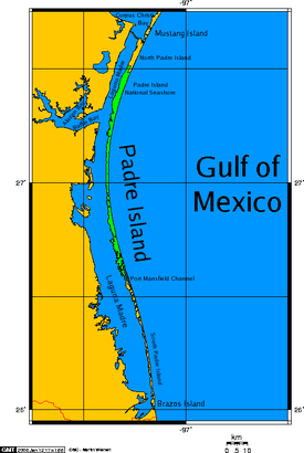
 Padre Island map, showing the Laguna Madre waters enclosed along the south Texas coast. | |
 | |
| Geography | |
|---|---|
| Location | Gulf of Mexico |
| Coordinates | 26°50′40″N 97°22′04″W / 26.84444°N 97.36778°W |
| Area | 209 sq mi (540 km2)(31st in U.S.) |
| Length | 113 mi (182 km) |
| Width | 1.61 mi (2.59 km) |
| Coastline | 263.22 mi (423.61 km) |
| Administration | |
United States | |
| State | Texas |
| Counties | Cameron, Kenedy, Kleberg, Nueces, Willacy |
| Additional information | |
| Official website | www |
| See: North and South Padre Island | |

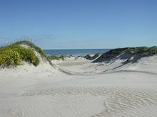
Padre Island is the largest of the Texas barrier islands and the world's longest barrier island. The island is located along Texas's southern coast of the Gulf of Mexico and is noted for its white sandy beaches. Meaning father in Spanish, it was named after Father José Nicolás Ballí (c.1770-1829), who owned the island and served as a missionary priest and collector of finances for all the churches in the Rio Grande Valley. He also founded the first mission in present-day Cameron County.[1]
Padre Island is the second-largest island by area in the contiguous United States, after Long Island in New York on the Atlantic Coast. It is about 113 miles (182 km) long[2][3]: 186 and 1.8 miles (3 km) wide,[4] stretching from the city of Corpus Christi, in the north, to the resort community of South Padre Island in the south. The island is oriented north-south, bordered by the Gulf of Mexico on the east and Laguna Madre on the west. The island's northern end connects to Mustang Island by roadway. The southern end of the island is separated from Brazos Island by the Brazos Santiago Pass.
The town of South Padre Island is located on its southern end, with the city of Corpus Christi situated at the northern end, but the island as a whole is sparsely populated. The central part of the island is preserved in a natural wild state as Padre Island National Seashore and part of the lower island is protected as part of the Laguna Atascosa National Wildlife Refuge. Since 1964, the island has been divided by the artificial Port Mansfield Channel. The terms "North Padre Island" and "South Padre Island" are often used to refer to the separated portions of the island. Padre Island is included within the jurisdictions of Cameron, Kenedy, Kleberg, Nueces, and Willacy counties in Texas.
- ^ "Ballí, José Nicolás". Handbook of Texas Online. Texas State Historical Society. Retrieved 2015-08-15.
- ^ * "Padre Island", Encyclopædia Britannica
- ^ Stanley Walker (February 1961). "The Fabulous State of Texas". National Geographic. Vol. 119, no. 2.
- ^ Garrison, J. R.; Williams, J.; Potter Miller, S.; Weber, E. T.; McMechan, G.; Zeng, X. (2010). "Ground-Penetrating Radar Study of North Padre Island: Implications for Barrier Island Internal Architecture, Model for Growth of Progradational Microtidal Barrier Islands, and Gulf of Mexico Sea-Level Cyclicity". Journal of Sedimentary Research. 80 (4): 303–319. Bibcode:2010JSedR..80..303G. doi:10.2110/jsr.2010.034.