Pā'ia, Hawaii
Pāʻia | |
|---|---|
 Downtown Paia | |
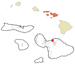
 Location in Maui County and the state of Hawaii | |
| Coordinates: 20°54′38″N 156°22′35″W / 20.91056°N 156.37639°W | |
| Country | United States |
| State | Hawaii |
| County | Maui |
| Area | |
• Total | 7.46 sq mi (19.33 km2) |
| • Land | 6.13 sq mi (15.88 km2) |
| • Water | 1.33 sq mi (3.45 km2) |
| Elevation | 230 ft (70 m) |
| Population (2020) | |
• Total | 2,470 |
| • Density | 402.87/sq mi (155.56/km2) |
| Time zone | UTC-10 (Hawaii-Aleutian) |
| ZIP code | 96779 |
| Area code | 808 |
| FIPS code | 15-60200 |
| GNIS feature ID | 0362968 |
Pā'ia (Hawaiian: Pāʻia [paːˈʔijə]) is a census-designated place (CDP) in Maui County, Hawaii, United States, on the northern coast of the island of Maui. The population was 2,470 at the 2020 census. Pā'ia is home to several restaurants, art galleries, surf shops and other tourist-oriented businesses. It was formerly home to a Hawaiian Commercial & Sugar mill from 1880 to 2000.[2][3]
Pā'ia is the first town on the Hana Highway when heading eastbound towards Hana.
Pā'ia is located close to many internationally known windsurfing spots including Hoʻokipa and Spreckelsville. It is therefore sometimes called "The World Capital of Windsurfing".[citation needed]
- ^ "2020 U.S. Gazetteer Files". United States Census Bureau. Retrieved December 18, 2021.
- ^ "History of Paia". Paia Town Association. Retrieved 2018-04-22.
- ^ "The History of Hawaiian Commercial & Sugar Co. | News, Sports, Jobs - Maui News". Retrieved 2018-04-22.