Paimpont
| |
|---|---|
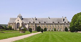
 Abbey | |
| Coordinates: 48°01′08″N 2°10′11″W / 48.0189°N 2.1697°W | |
| Country | France |
| Region | Brittany |
| Department | Ille-et-Vilaine |
| Arrondissement | Rennes |
| Canton | Montfort-sur-Meu |
| Intercommunality | Brocéliande |
| Government | |
| • Mayor (2020–2026) | Alain Lefeuvre[1] |
Area 1 | 110.28 km2 (42.58 sq mi) |
| Population (2021)[2] | 1,781 |
| • Density | 16/km2 (42/sq mi) |
| Time zone | UTC+01:00 (CET) |
| • Summer (DST) | UTC+02:00 (CEST) |
| INSEE/Postal code | 35211 /35380 |
| Elevation | 62–258 m (203–846 ft) (avg. 160 m or 520 ft) |
| 1 French Land Register data, which excludes lakes, ponds, glaciers > 1 km2 (0.386 sq mi or 247 acres) and river estuaries. | |
Paimpont (French pronunciation: [pɛ̃pɔ̃]; Breton: Pempont; Gallo: Penpont) is a commune in the Ille-et-Vilaine department in Brittany in northwestern France.
The name is a compound of Old Breton pen "head" and the Latin borrowing pont "bridge" and is first attested in the 9th century in the Latinised form Caput Pontis and then in 870 CE as Penpont.[3] The town grew up around the abbey of Our Lady of Paimpont, which was founded by the Breton king and Catholic saint Judicael in 645 CE on the shore of a small lake now known as the Étang de Paimpont.[4]
- ^ "Répertoire national des élus: les maires" (in French). data.gouv.fr, Plateforme ouverte des données publiques françaises. 13 September 2022.
- ^ "Populations légales 2021" (in French). The National Institute of Statistics and Economic Studies. 28 December 2023.
- ^ Dauzat, Albert; Rostaing, Charles (1979). Dictionnaire étymologique des noms de lieu en France. Paris: Librairie Guénégaud. pp. 515–6. ISBN 2-85023-076-6.
- ^ "Abbaye de Paimpont". Brocéliande (in French). Retrieved 14 August 2020.


