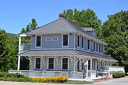
Paint Bank, Virginia | |
|---|---|
 Former train station | |
| Coordinates: 37°34′8″N 80°15′43″W / 37.56889°N 80.26194°W | |
| Country | United States |
| State | Virginia |
| County | Craig |
| Elevation | 1,847 ft (563 m) |
| Time zone | UTC-5 (Eastern (EST)) |
| • Summer (DST) | UTC-4 (EDT) |
| ZIP code | 24131 |
| Area code | 540 |
| GNIS feature ID | 1486039[1] |
| USGS[2] | |
Paint Bank is an unincorporated community in northern Craig County, Virginia, United States. It is located at the intersection of State Route 18 and State Route 311 northwest of the town of New Castle, the county seat.[3] The village is located between Potts Mountain and Peters Mountain. It is one of the westernmost communities of the Roanoke metropolitan area.
- ^ "US Board on Geographic Names". United States Geological Survey. October 25, 2007. Retrieved January 31, 2008.
- ^ USGS. "Geographic Names Information System Feature Detail Report: Paint Bank". Retrieved July 19, 2008.
- ^ "Google Maps". Retrieved July 19, 2008.

