Pakur district | |
|---|---|
 A stone-quarrying unit in Pakur district | |
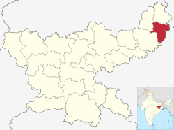
 Location of Pakur district in Jharkhand | |
| Country | |
| State | |
| Division | Santhal Pargana |
| Headquarters | Pakur |
| Government | |
| • Deputy Commissioner | Shri. Manish Kumar (IAS) |
| • Lok Sabha constituencies | Rajmahal (shared with Sahebganj district) |
| • Vidhan Sabha constituencies | 3 |
| Area | |
• Total | 1,805.59 km2 (697.14 sq mi) |
| Population (2011)[1] | |
• Total | 900,422 |
| • Density | 500/km2 (1,300/sq mi) |
| • Urban | 5.13% |
| Demographics | |
| • Literacy | 48.82 per cent |
| • Sex ratio | 989 |
| Time zone | UTC+05:30 (IST) |
| Website | pakur |
Pakur district is one of the twenty-four districts of Jharkhand state, India, and Pakur is the administrative headquarters of this district. Pakur sub-division of Sahibganj district was carved out on 28 January 1994 to constitute Pakur District. The district, with a population of 900,422 (census 2011), and covering an area of 686.21 km2, is situated on the north-eastern corner of Jharkhand state.