| Palinuro | |
|---|---|
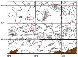
 Aeolian arc, including coastline and depth contour lines for every 500 meters. | |
| Summit depth | 70 m (230 ft) |
| Location | |
| Location | Tyrrhenian Sea |
| Coordinates | 39°29′04″N 14°49′44″E / 39.48444°N 14.82889°E[1] |
Palinuro Seamount is a seamount in the Tyrrhenian Sea. It is an elongated 50–70 km (31–43 mi) long complex of volcanoes north of the Aeolian Islands with multiple potential calderas. The shallowest point lies at 80–70 m (260–230 ft) depth and formed an island during past episodes of low sea level. Palinuro was active during the last 800,000 years and is likely the source for a 10,000 years old tephra layer in Italy. Ongoing seismicity occurs at the seamount, which may be a tsunami hazard. The volcanic activity may somehow relate to the subduction of the Ionian Sea farther east.
Diffuse hydrothermal activity takes place on Palinuro Seamount, which has led to the deposition of sulfide deposits in the seafloor that could be used as a source of ores for rare metals. Italy has declared the seamount a protected area, where algae and deep water corals occur.
- ^ Würtz 2015, p. 113.
