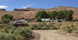
Palisade, Nevada | |
|---|---|
 | |
| Coordinates: 40°36′37″N 116°11′55″W / 40.61028°N 116.19861°W | |
| Country | United States |
| State | Nevada |
| County | Eureka |
| Elevation | 4,853 ft (1,479 m) |
| Time zone | UTC-8 (Pacific (PST)) |
| • Summer (DST) | UTC-7 (PDT) |
| GNIS feature ID | 847450[1] |
| Reference no. | 65 |
Palisade (originally called Palisades) is located in Eureka County in the northeastern section of the state of Nevada, in the western United States. It is about 10 miles (16 km) south of Carlin, and about 33 miles (53 km) southwest of Elko. Although now a virtual ghost town, it had a rich history following construction of the Transcontinental Railroad. The town takes its name from Palisade Canyon[2] (also called "12-Mile" and "10-Mile Canyon"), an important obstacle to the construction and operation of the railroad, which lies to the west.
- ^ a b U.S. Geological Survey Geographic Names Information System: Palisade, Nevada
- ^ Federal Writers' Project (1941). Origin of Place Names: Nevada (PDF). W.P.A. p. 35.
