| Palo Duro Canyon | |
|---|---|
 View from the Interpretive Center | |
| Floor elevation | 2,828 ft (862 m) |
| Length | 120 mi (190 km) |
| Width | 20 mi (32 km) |
| Depth | 800 ft (240 m)[1] |
| Geography | |
| Coordinates | 34°57′N 101°40′W / 34.950°N 101.667°W |
| Rivers | Prairie Dog Town Fork Red River |
| Designated | 1976 |
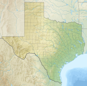
Palo Duro Canyon is a canyon system of the Caprock Escarpment located in the Texas Panhandle near the cities of Amarillo and Canyon.[2] As one of the largest canyons in the United States, it is roughly 25–40 mi (40–64 km) long and has an average width of 6 mi (9.7 km), but reaches a width of 20 mi (32 km) at places. Its depth is around 800 ft (240 m),[1] but in some locations, valley bottom to surrounding hills increases to 1,000 ft (300 m). Palo Duro Canyon (from the Spanish meaning "hard stick")[3] has been named "The Grand Canyon of Texas" both for its size and for its dramatic geological features, including the multicolored layers of rock and steep mesa walls, which are similar to those in the Grand Canyon. It is part of Palo Duro Canyon State Park. The State Park had 442,242 visitors in 2022.[4]
- ^ a b "Palo Duro Canyon State Park Nature — Texas Parks & Wildlife Department".
- ^ "Palo Duro Canyon State Park — Texas Parks & Wildlife Department". Tpwd.state.tx.us. Retrieved September 29, 2018.
- ^ "Palo Duro Canyon State Park". Palodurocanyon.com. Retrieved September 29, 2018.
- ^ Christopher Adams (February 24, 2023). "What is the most visited state park in Texas? Here's the top 10 countdown". KXAN.com. Retrieved November 21, 2023.

