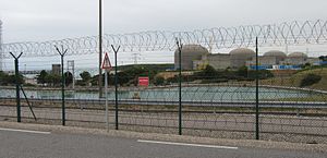
| Paluel Nuclear Power Plant | |
|---|---|
 | |
 | |
| Official name | Centrale Nucléaire de Paluel |
| Country | France |
| Location | Paluel, Seine-Maritime, Normandy |
| Coordinates | 49°51′29″N 0°38′8″E / 49.85806°N 0.63556°E |
| Status | Operational |
| Construction began | Unit 1: 15 August 1977 Unit 2: 1 January 1978 Unit 3: 1 February 1979 Unit 4: 1 February 1980 |
| Commission date | Units 1–2: 1 December 1985 Unit 3: 1 February 1986 Unit 4: 1 June 1986 |
| Owner | EDF |
| Operator | EDF |
| Nuclear power station | |
| Reactor type | PWR |
| Reactor supplier | Framatome |
| Cooling source | English Channel |
| Thermal capacity | 4 × 3817 MWth |
| Power generation | |
| Units operational | 4 × 1330 MW |
| Make and model | P4 REP 1300 |
| Nameplate capacity | 5320 MW |
| Capacity factor | 68.53% (lifetime) |
| Annual net output | 21,218 GWh (2017) |
| External links | |
| Website | Centrale nucléaire de Paluel |
| Commons | Related media on Commons |
The Paluel Nuclear Power Plant (French: Centrale nucléaire de Paluel) lies within the French town Paluel in Normandy in the Département Seine-Maritime. The nuclear power plant, which consists of four 1330 MWe class pressurized water reactors, is about 40 kilometers far away from the city of Dieppe and employs approx. 1,250 full-time workers. The operator is the French company EDF. Water from the English Channel is used for cooling.