Panaca, Nevada | |
|---|---|
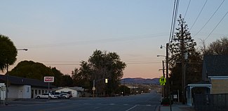
 Main Street in Panaca, 2012 | |
| Coordinates: 37°47′28″N 114°23′20″W / 37.79111°N 114.38889°W | |
| Country | |
| State | |
| County | Lincoln |
| Area | |
| • Total | 7.98 km2 (3.08 sq mi) |
| • Land | 7.98 km2 (3.08 sq mi) |
| • Water | 0.00 km2 (0.00 sq mi) |
| Population (2020) | |
| • Total | 870 |
| • Density | 109.07/km2 (282.47/sq mi) |
| Time zone | UTC−8 (Pacific (PST)) |
| • Summer (DST) | UTC−7 (PDT) |
| ZIP code | 89042 |
| Area code | 775 |
| FIPS code | 32-54200 |
| GNIS feature ID | 2583949[2] |
| Website | www |
| Reference no. | 39 |
Panaca is an unincorporated town[3] in eastern Lincoln County, Nevada, United States, on State Route 319, about 1 mile (1.6 kilometers) east of U.S. Route 93, near the border with Utah. Its elevation is 4,729 feet (1,441 meters) above sea level. As of the 2010 census, it had a population of 963.[4] It is one of only two cities in Nevada that prohibits gambling, the other being Boulder City.[5]
- ^ "ArcGIS REST Services Directory". United States Census Bureau. Retrieved September 19, 2022.
- ^ U.S. Geological Survey Geographic Names Information System: Panaca, Nevada
- ^ "Lincoln County Code - Section 1-5-3: Panaca". Sterling Codifiers. Retrieved January 27, 2017.
- ^ "Geographic Identifiers: 2010 Demographic Profile Data (G001): Panaca CDP, Nevada". U.S. Census Bureau, American Factfinder. Archived from the original on February 12, 2020. Retrieved January 25, 2013.
- ^ Jamie., Jensen (January 1, 2006). Road trip USA : cross-country adventures on America's two-lane highways. Avalon Travel. ISBN 9781566917667. OCLC 74323111.

