| Panania Sydney, New South Wales | |||||||||||||||
|---|---|---|---|---|---|---|---|---|---|---|---|---|---|---|---|
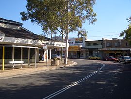
 Shops and post office in Panania c. 2007 | |||||||||||||||
 | |||||||||||||||
| Population | 13,507 (2021 census)[1] | ||||||||||||||
| Postcode(s) | 2213 | ||||||||||||||
| Elevation | 23 m (75 ft) | ||||||||||||||
| Location | 23 km (14 mi) south-west of Sydney CBD | ||||||||||||||
| LGA(s) | City of Canterbury-Bankstown | ||||||||||||||
| State electorate(s) | East Hills | ||||||||||||||
| Federal division(s) | Banks | ||||||||||||||
| |||||||||||||||
Panania (/pəneɪniə/), a suburb of local government area City of Canterbury-Bankstown, is located 23 kilometres inner south-west of the Sydney central business district, in the state of New South Wales, Australia, and is a part of the South-western Sydney region. The postcode is 2213, which it shares with adjacent suburbs East Hills and Picnic Point.
Panania is bounded on the north by the M5 South Western Motorway and the suburb of Milperra. Picnic Point, to the south, features parklands along the Georges River. East Hills is the suburb to the west and Revesby is located to the east.