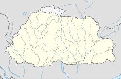
Pangda
庞达 | |
|---|---|
Village | |
 Doklam area | |
| Coordinates: 27°18′25.1994″N 89°0′28.7994″E / 27.306999833°N 89.007999833°E | |
| Country | Unknown |
| Elevation | 2,140 m (7,020 ft) |
| Population | |
| • Estimate (2020) | 124 |
Pangda (庞达村) is a village constructed by China in the Doklam region near the India-Bhutan-China trijunction. It is approximately 10 km east of the trijunction in territory claimed by China but shown as part of Bhutan in international maps. The village was constructed in 2020 on the bank of the Amo Chhu river (or Torsa River).
Media reports in November 2020 said that the village was constructed approximately 2 kilometres (1.2 mi) within Bhutanese territory based on third-party satellite images.[1][2][3][4] This was later denied by Bhutan and China.[2][3][4]
- ^ "China Sets Up Village Within Bhutan, 9 Km From Doklam Face-Off Site". NDTV.com. Retrieved 2020-11-24.
- ^ a b Cite error: The named reference
:0was invoked but never defined (see the help page). - ^ a b Cite error: The named reference
:1was invoked but never defined (see the help page). - ^ a b Zhen, Liu; Purohit, Kunal (6 December 2020). "Near the China-Bhutan-India border, a new village is drawing attention to old disputes". South China Morning Post. Retrieved 7 December 2020.
