Panjshir
پنجشیر | |
|---|---|
 Clockwise: the Panjshir valley, the Panjshir River, the tomb of Ahmad Shah Massoud, and a Panjshir wind farm | |
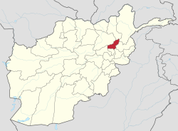
 Map of Afghanistan with Panjshir highlighted | |
| Coordinates: 35°25′39″N 69°44′06″E / 35.42750°N 69.73500°E | |
| Country | |
| Capital | Bazarak |
| Government | |
| • Governor | qari saheb asrar [1] |
| • Deputy Governor | Qari Asrar[2] |
| Area | |
• Total | 3,771 km2 (1,456 sq mi) |
| Population (2021)[3] | |
• Total | 172,895 |
| • Density | 46/km2 (120/sq mi) |
| Time zone | UTC+4:30 (Afghanistan Time) |
| Postal code | 15XX |
| ISO 3166 code | AF-PAN[4] |
| Main languages | Dari |
Panjshir (Dari: پنجشیر, literally "Five Lions," pronounced /pand͡ʒʃeːɾ/, also spelled as Panjsher) is one of the thirty-four provinces of Afghanistan, located in the northeastern part of the country containing the Panjshir Valley. The province is divided into seven districts and contains 512 villages. As of 2021, the population of Panjshir province was about 173,000.
Panjshir became an independent province from neighboring Parwan Province in 2004. It is bordered by Baghlan and Takhar in the north, Badakhshan and Nuristan in the east, Laghman and Kapisa in the south, and Parwan in the west.
- ^ "UN Official Visits Panjshir Province & Meets Taliban's Governor". Afghanistan International. 17 November 2023. Retrieved 15 April 2024.
- ^ "د پنجشير ولايت اړمنو خلکو او داخلي بې ځايه شويو سره د مرستو او ستونزو د حل په موخه د کډوالو او راستنېدونکو چارو وزارت په مشرۍ يو ګډ پلاوي دی ولايت ته سفر وکړ | د مهاجرینو او راستنېدونکو چارو وزارت". morr.gov.af. Retrieved 13 June 2023.
- ^ Cite error: The named reference
nsiawas invoked but never defined (see the help page). - ^ "AF - Afghanistan". ISO Online Browsing Platform. Retrieved 16 December 2021.