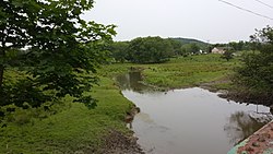
| Papakating Creek Pepper-Cotton, Pellettown Creek, Pellet Creek | |
|---|---|
 Looking south from County Route 565 in Wantage Township | |
 | |
| Etymology | Munsee (northern Lenape dialect) |
| Location | |
| Country | United States |
| State | New Jersey |
| County | Sussex |
| Municipality | Frankford Township, Wantage Township |
| Physical characteristics | |
| Source | Frankford Township, at foot of Kittatinny Mountain |
| • coordinates | 41°12′36″N 74°43′02″W / 41.21000°N 74.71722°W |
| • elevation | 900 ft (270 m) |
| Mouth | Wallkill River, E of Sussex borough |
• coordinates | 41°12′05″N 74°34′35″W / 41.20139°N 74.57639°W |
• elevation | 387 ft (118 m) |
| Length | 20.1 mi (32.3 km) |
| Basin size | 60.6 sq mi (157 km2) |
| Basin features | |
| River system | Wallkill River (tributary of Rondout Creek, Hudson River) |
| Tributaries | |
| • left | Clove Brook, Neepaulakating Creek, West Branch Papakating Creek |
| [a][1] | |
Papakating Creek is a 20.1-mile-long (32.3 km) tributary of the Wallkill River located in Frankford and Wantage townships in Sussex County, New Jersey in the United States. The creek rises in a small swamp located beneath the eastern face of Kittatinny Mountain in Frankford and its waters join the Wallkill to the east of Sussex borough.
Papakating Creek and its three major tributaries drain the northern portion of New Jersey's Kittatinny Valley a fertile valley underlain by shale and limestone of the Ordovician Martinsburg Formation and soils deposited by retreating glaciers in the last ice age. The region which the Papakating Creek and its tributaries drain is largely rural farmland and forests with a few low-density residential communities. The New Jersey Department of Environmental Protection reports that phosphorus and fecal coliform from agricultural or residential runoff as well as arsenic from agricultural pesticide applications or regional mineralogy impair the creek. Within the watershed are lands belonging to two state parks, one federal wildlife refuge, and preserves managed by the New Jersey Natural Lands Trust which set aside tracts for wildlife habitats that protect unique ecosystems and some threatened species.
Cite error: There are <ref group=lower-alpha> tags or {{efn}} templates on this page, but the references will not show without a {{reflist|group=lower-alpha}} template or {{notelist}} template (see the help page).
- ^ United States Geological Survey, Geographic Names Information System, Feature Detail Report for: Papakating Creek (879110). Retrieved July 25, 2015.