This article needs additional citations for verification. (March 2023) |
Papakura District | |
|---|---|
Former local council territory | |
 Sign marking former Papakura District Boundary. | |
 Territorial Authority location | |
| Coordinates: 37°05′S 174°57′E / 37.083°S 174.950°E | |
| Country | New Zealand |
| Main town | Papakura |
| Other towns | Alfriston, Drury, Pahurehure, Ardmore, Redhill, Takanini |
| Government | |
| • Mayor | Calum Penrose (final mayor at the time the position was abolished when the district was absorbed into Auckland Council in 2010) |
| Area (in 2010) | |
| • Total | 123 km2 (47 sq mi) |
| Extent was Takanini to Drury; Pahurehure to Ardmore/Alfriston | |
| Population (June 2018[1]) | |
| • Papakura (central) | 28,010 |
| • Takanini | 10,870 |
| Council address | 35 Coles Cres, Private Bag 92300, Auckland 1142 |
| Website | www |
| See also: Manukau City, Franklin | |


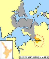
Papakura District was a local council territory in New Zealand's Auckland Region that was governed by the Papakura District Council from 1989 until 2010. The area makes up the southernmost part of the Auckland metropolitan area.
The area was originally a small independent city, until it became Papakura District in the 1989 reorganisation of New Zealand's local governments, and has now been overtaken by Auckland's urban sprawl. The district is flanked by beaches on the Manukau Harbour to the west, Manukau City to the north and east, and had Franklin District to the south.
- ^ "Subnational Population Estimates: At 30 June 2019". Statistics New Zealand. 22 October 2019. Retrieved 11 January 2020. For urban areas, "Subnational population estimates (UA, AU), by age and sex, at 30 June 1996, 2001, 2006–18 (2017 boundaries)". Statistics New Zealand. 23 October 2018. Retrieved 23 October 2018.