Paralia
Παραλία | |
|---|---|
 | |
| Coordinates: 40°16′N 22°35′E / 40.267°N 22.583°E | |
| Country | Greece |
| Administrative region | Central Macedonia |
| Regional unit | Pieria |
| Municipality | Katerini |
| Area | |
| • Municipal unit | 24.344 km2 (9.399 sq mi) |
| • Community | 1.849 km2 (0.714 sq mi) |
| Elevation | 14 m (46 ft) |
| Population (2021)[1] | |
| • Municipal unit | 6,228 |
| • Municipal unit density | 260/km2 (660/sq mi) |
| • Community | 928 |
| • Community density | 500/km2 (1,300/sq mi) |
| Time zone | UTC+2 (EET) |
| • Summer (DST) | UTC+3 (EEST) |
| Postal code | 601 50 |
| Area code(s) | 23510 |
| Vehicle registration | KN |
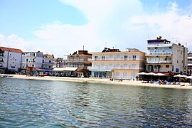
Paralia (Greek: Παραλία, Paralía, meaning "beach") is a tourist seaside settlement and a former municipality in the eastern part of the Pieria regional unit, Greece. Since the 2011 local government reform it is part of the municipality Katerini, of which it is a municipal unit.[2] The seat of the municipality was in Kallithea. The 2021 census reported a population of 928 for the community of Paralia, and 6,228 for the municipal unit.[3] The municipal unit has an area of 24.344 km2, the community 1.849 km2.[4] Paralia Katerinis actually translated "Beach of Katerini" and is the closest beach to the capital city of Katerini.
- ^ "Αποτελέσματα Απογραφής Πληθυσμού - Κατοικιών 2021, Μόνιμος Πληθυσμός κατά οικισμό" [Results of the 2021 Population - Housing Census, Permanent population by settlement] (in Greek). Hellenic Statistical Authority. 29 March 2024.
- ^ "ΦΕΚ B 1292/2010, Kallikratis reform municipalities" (in Greek). Government Gazette.
- ^ Cite error: The named reference
census11was invoked but never defined (see the help page). - ^ "Population & housing census 2001 (incl. area and average elevation)" (PDF) (in Greek). National Statistical Service of Greece.

