Paranapiacaba | |
|---|---|
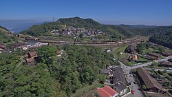
 A view of Paranapiacaba village, in Santo André, Brazil. | |
| Coordinates: 23°46′40″S 46°18′05″W / 23.77778°S 46.30139°W | |
| Country | |
| State | |
| Area | |
| • Total | 84.464 km2 (32.612 sq mi) |
| Population (2022)[1] | |
| • Total | 2,458 |
| • Density | 29/km2 (75/sq mi) |
| Time zone | UTC-3 |
Paranapiacaba is a district of the municipality of Santo André in the Brazilian state of São Paulo.[2][3] It is located approximately 61 kilometres (38 mi) by road southeast of the centre of the city of São Paulo, and about 12 kilometres (7.5 mi) east of Rio Grande da Serra. The word paranapiacaba means "where you will find the sea" in Tupi.[4]
Paranapiacaba was established as a company town for the employees of São Paulo Railway, a privately owned British railway company. A large industrial complex, which the district is known for, lies off the main road from Rio Grande da Serra, on the way into the main village. The growth of this centre was facilitated by the railway, transporting cargo and people from São Paulo Interior to the port of Santos. The village design has been characterized as being panoptic.[5]
- ^ "2022 Census | IBGE". www.ibge.gov.br. Retrieved 2024-06-15.
- ^ "Territorial division". geoftp.ibge.gov.br. Retrieved 2024-06-15.
- ^ "Maps of municipalities". geoftp.ibge.gov.br. Retrieved 2024-06-15.
- ^ Cite error: The named reference
GosseriesVanderborght2011was invoked but never defined (see the help page). - ^ Cite error: The named reference
Schelling2000was invoked but never defined (see the help page).