Pardesiya
| |
|---|---|
Local council (from 1952) | |
| Hebrew transcription(s) | |
| • ISO 259 | Pardesiya |
 | |
| Coordinates: 32°18′30″N 34°54′35″E / 32.30833°N 34.90972°E | |
| Country | |
| District | Central |
| Founded | 1938 |
| Government | |
| • Head of Municipality | Tal Gorki |
| Area | |
| • Total | 1,273 dunams (1.273 km2 or 315 acres) |
| Population (2022)[1] | |
| • Total | 7,421 |
| • Density | 5,800/km2 (15,000/sq mi) |
| Name meaning | Orchard place |
| Website | [1] |
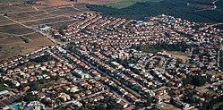
Pardesiya (Hebrew: פַּרְדֵּסִיָּה) is a town in the Central District of Israel. Located on the Sharon plain, between Kfar Yona and the Lev HaSharon Regional Council, it was founded between 1937 and 1939.[2] In 2022 it had a population of 7,421;[1] its jurisdiction is 1,273 dunams (~1.3 km2)[3]
- ^ a b "Regional Statistics". Israel Central Bureau of Statistics. Retrieved 21 March 2024.
- ^ HaReuveni, Immanuel (1999). Lexicon of the Land of Israel (in Hebrew). Miskal - Yedioth Ahronoth Books and Chemed Books. pp. 799–800. ISBN 965-448-413-7.
- ^ Cite error: The named reference
profilewas invoked but never defined (see the help page).

