Parguera | |
|---|---|
Barrio | |
 On the water in Parguera | |
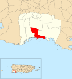
 Location of Parguera within the municipality of Lajas shown in red | |
| Coordinates: 17°58′33″N 67°02′31″W / 17.975944°N 67.041922°W[1] | |
| Commonwealth | |
| Municipality | |
| Area | |
| • Total | 7.34 sq mi (19.0 km2) |
| • Land | 4.02 sq mi (10.4 km2) |
| • Water | 3.32 sq mi (8.6 km2) |
| Elevation | 36 ft (11 m) |
| Population (2010) | |
| • Total | 2,082 |
| • Density | 519.2/sq mi (200.5/km2) |
| Source: 2010 Census | |
| Time zone | UTC−4 (AST) |
Parguera is a barrio in the municipality of Lajas, Puerto Rico with a population of 2,082 in 2010.[3] La Parguera is the main settlement of the barrio, often referred to as Poblado de la Parguera. Parguera is home to La Parguera Nature Reserve, which encompasses the bioluminescent bay, its surrounding mangrove forests, wetlands and a number of keys such as Mata La Gata and Cayo Enrique. The name Parguera derives from pargo, the local name for the Northern red snapper (Lutjanus campechanus).[4]
- ^ a b "US Gazetteer 2019". US Census. US Government.
- ^ U.S. Geological Survey Geographic Names Information System: Parguera barrio
- ^ Puerto Rico: 2010 Population and Housing Unit Counts.pdf (PDF). U.S. Dept. of Commerce, Economics and Statistics Administration, U.S. Census Bureau. 2010.
- ^ López, Por Roberto (11 September 2014). "La Parguera, destino en Puerto Rico". Viaje a América (in Spanish). Retrieved 15 December 2021.
