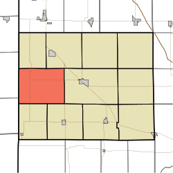
Parish Grove Township | |
|---|---|
 Location of Parish Grove Township in Benton County | |
| Coordinates: 40°36′28″N 87°27′25″W / 40.60778°N 87.45694°W | |
| Country | United States |
| State | Indiana |
| County | Benton |
| Organized | July 1840 |
| Government | |
| • Type | Indiana township |
| Area | |
| • Total | 45.44 sq mi (117.7 km2) |
| • Land | 45.42 sq mi (117.6 km2) |
| • Water | 0.01 sq mi (0.03 km2) |
| Elevation | 745 ft (227 m) |
| Population (2020) | |
| • Total | 185 |
| • Density | 4.1/sq mi (1.6/km2) |
| Time zone | UTC-5 (EST) |
| • Summer (DST) | UTC-4 (EDT) |
| FIPS code | 18-57942[2] |
| GNIS feature ID | 453706 |
Parish Grove Township is one of eleven townships in Benton County, Indiana. As of the 2020 census, its population was 185 and it contained 89 housing units.[3] It contains the unincorporated town of Freeland Park.
| Census | Pop. | Note | %± |
|---|---|---|---|
| 1890 | 648 | — | |
| 1900 | 778 | 20.1% | |
| 1910 | 922 | 18.5% | |
| 1920 | 880 | −4.6% | |
| 1930 | 853 | −3.1% | |
| 1940 | 715 | −16.2% | |
| 1950 | 683 | −4.5% | |
| 1960 | 636 | −6.9% | |
| 1970 | 510 | −19.8% | |
| 1980 | 395 | −22.5% | |
| 1990 | 312 | −21.0% | |
| 2000 | 267 | −14.4% | |
| 2010 | 241 | −9.7% | |
| 2020 | 185 | −23.2% | |
| Source: US Decennial Census[4] | |||
- ^ "US Board on Geographic Names". United States Geological Survey. October 25, 2007. Retrieved January 31, 2008.
- ^ "U.S. Census website". United States Census Bureau. Retrieved January 31, 2008.
- ^ "Explore Census Data". US Census Bureau. Retrieved February 18, 2022.
- ^ "Township Census Counts: STATS Indiana".