Paros
Πάρος | |
|---|---|
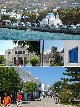
 From top left: Parikia, Panagia Ekatontapiliani, the Frankish Castle and a typical Paros street | |
| Coordinates: 37°4′N 25°12′E / 37.067°N 25.200°E | |
| Country | Greece |
| Administrative region | South Aegean |
| Regional unit | Paros |
| Area | |
• Municipality | 196.3 km2 (75.8 sq mi) |
| Highest elevation | 724 m (2,375 ft) |
| Lowest elevation | 0 m (0 ft) |
| Population (2021)[1] | |
• Municipality | 14,520 |
| • Density | 74/km2 (190/sq mi) |
| • Community | 6,204 |
| Demonym | Parian |
| Time zone | UTC+2 (EET) |
| • Summer (DST) | UTC+3 (EEST) |
| Postal code | 844 00 |
| Area code(s) | 22840 |
| Vehicle registration | EM |
| Website | www |
Paros (/ˈpɛərɒs/; Greek: Πάρος [ˈparos]; Venetian: Paro) is a Greek island in the central Aegean Sea. Part of the Cyclades island group, it lies to the west of Naxos, from which it is separated by a channel about 8 kilometres (5 miles) wide.[2] It lies approximately 150 km (93 miles) south-east of Piraeus. The Municipality of Paros includes numerous uninhabited offshore islets totaling 196.308 square kilometres (75.795 sq mi) of land.[3] Its nearest neighbor is the municipality of Antiparos, which lies to its southwest. In ancient Greece, the city-state of Paros was located on the island.[4]
Historically, Paros was known for its fine white marble, which gave rise to the term Parian to describe marble or china of similar qualities.[5] Today, abandoned marble quarries and mines (with some still being in use) can be found on the island, but Paros is primarily known as a popular tourist spot.
- ^ "Αποτελέσματα Απογραφής Πληθυσμού - Κατοικιών 2021, Μόνιμος Πληθυσμός κατά οικισμό" [Results of the 2021 Population - Housing Census, Permanent population by settlement] (in Greek). Hellenic Statistical Authority. 29 March 2024.
- ^ Chisholm, Hugh, ed. (1911). . Encyclopædia Britannica. Vol. 20 (11th ed.). Cambridge University Press. pp. 860–861.
- ^ "Population & housing census 2001 (incl. area and average elevation)" (PDF) (in Greek). Hellenic Statistical Authority.
- ^ Lund University. Digital Atlas of the Roman Empire.
- ^ "Parian". The Free Dictionary. Retrieved 2009-05-06.

