Parua Bay | |
|---|---|
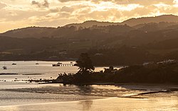
 Parua Bay, showing the Pacific oyster aquaculture farm | |
 | |
| Coordinates: 35°46′12″S 174°27′33″E / 35.77000°S 174.45917°E | |
| Country | New Zealand |
| Region | Northland Region |
| District | Whangarei District |
| Ward | Whangarei Heads Ward |
| Electorates | |
| Government | |
| • Territorial Authority | Whangarei District Council |
| • Regional council | Northland Regional Council |
| Area | |
| • Total | 1.87 km2 (0.72 sq mi) |
| Population (June 2024)[2] | |
| • Total | 660 |
| • Density | 350/km2 (910/sq mi) |
Parua Bay is a locality and bay on the northern side of the Whangārei Harbour in Northland, New Zealand. Whangārei is 19 km to the west, and Whangārei Heads are 10 km to the south east, with Munro Bay between the two. The western head is called Manganese Point, and the eastern is Reserve Point. The Nook is a small bay just to the north of Reserve Point.[3][4]
The bay is sheltered and about 4 km wide, with about one kilometre between the headlands. The central bay has deep water, but there are wide intertidal zones around the coast. Motukiore Island is just inside Manganese Point and joined to it by a causeway at low tide, although the only practical access is by water. The contours of a defensive pā on the island are still clearly visible.[5]
Solomon's Point divides the bay into two. The point is named after the Māori chief Horomona-Kaikou.[5]
- ^ Cite error: The named reference
Areawas invoked but never defined (see the help page). - ^ "Aotearoa Data Explorer". Statistics New Zealand. Retrieved 26 October 2024.
- ^ Peter Dowling, ed. (2004). Reed New Zealand Atlas. Reed Books. pp. map 8. ISBN 0-7900-0952-8.
- ^ Roger Smith, GeographX (2005). The Geographic Atlas of New Zealand. Robbie Burton. pp. map 28. ISBN 1-877333-20-4.
- ^ a b Parkes, W. F. (1992). Guide to Whangarei City and District. pp. 28–30. ISBN 0-473-01639-7.