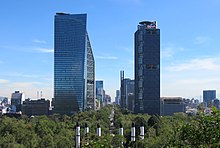
 Paseo de la Reforma as seen from Chapultepec Castle | |
| Length | 14.7 km (9.1 mi) |
| Location | Mexico City, Mexico |
| Nearest metro station | Auditorio, Garibaldi / Lagunilla, Hidalgo |
| Coordinates | 19°26′04″N 99°09′07″W / 19.43444°N 99.15194°W |

Paseo de la Reforma (literally "Promenade of the Reform") is a wide avenue that runs diagonally across the heart of Mexico City. It was designed at the behest of Emperor Maximilian by Ferdinand von Rosenzweig during the era of the Second Mexican Empire and modeled after the great boulevards of Europe,[1] such as the Ringstraße in Vienna and the Champs-Élysées in Paris. The planned grand avenue was to link the National Palace with the imperial residence, Chapultepec Castle, which was then on the southwestern edge of town. The project was originally named Paseo de la Emperatriz ("Promenade of the Empress") in honor of Maximilian's consort Empress Carlota. After the fall of the Empire and Maximilian's subsequent execution, the Restored Republic renamed the Paseo in honor of the La Reforma.
It is now home to many of Mexico's tallest buildings such as the Torre Mayor and others in the Zona Rosa. More modern extensions continue the avenue at an angle to the old Paseo. To the northeast it continues toward Tlatelolco, where it changes its name near the Plaza de las Tres Culturas. There it divides into Calzada de Guadalupe and Calzada de los Misterios that continue toward La Villa. Its western portion going west from Chapultepec Park passes south of Polanco on its way through the affluent neighborhood of Lomas de Chapultepec and then into Cuajimalpa and Santa Fe on the outskirts of the city, although when it reaches this point it is more a highway than a promenade.
- ^ "Excélsior en la Historia: La metamorfosis de Paseo de la Reforma". Excélsior. 31 July 2013. Retrieved 10 April 2015.