Passes-Dangereuses | |
|---|---|
 Ste-Élisabeth-de-Proulx | |
 | |
| Coordinates: 48°58′N 72°04′W / 48.967°N 72.067°W[1] | |
| Country | Canada |
| Province | Quebec |
| Region | Saguenay–Lac-Saint-Jean |
| RCM | Maria-Chapdelaine |
| Constituted | unspecified |
| Government | |
| • Federal riding | Roberval—Lac-Saint-Jean |
| • Prov. riding | Lac-Saint-Jean and Roberval |
| Area | |
| • Total | 16,857.50 km2 (6,508.72 sq mi) |
| • Land | 15,579.11 km2 (6,015.13 sq mi) |
| Population (2021)[3] | |
| • Total | 210 |
| • Density | 0.0/km2 (0/sq mi) |
| • Pop (2016–21) | |
| • Dwellings | 151 |
| Time zone | UTC−05:00 (EST) |
| • Summer (DST) | UTC−04:00 (EDT) |
| Area code(s) | 418 and 581 |
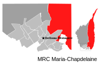
Passes-Dangereuses (French pronunciation: [pas dɑ̃ʒʁøz]; until May 2009: Chute-des-Passes[4]) is an unorganized territory in the Canadian province of Quebec, located between the Peribonka River on the east and the Mistassibi River on the west.
- ^ Cite error: The named reference
toponymiewas invoked but never defined (see the help page). - ^ a b Ministère des Affaires municipales, des Régions et de l'Occupation du territoire - Répertoire des municipalités: Passes-Dangereuses Archived 2016-03-04 at the Wayback Machine
- ^ a b "Chute-des-Passes census profile". 2021 Census data. Statistics Canada. Retrieved 2022-03-21.
- ^ http://www.stat.gouv.qc.ca/publications/referenc/pdf2009/modif_mai09.pdf[permanent dead link]
