This article contains translated text and the factual accuracy of the translation should be checked by someone fluent in Indonesian and English. (January 2023) |
Pasupati Bridge Jembatan Pasupati | |
|---|---|
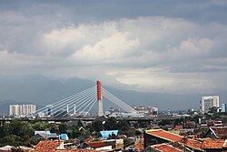
 The Pasupati Bridge on top of resident houses. | |
| Coordinates | 6°53′56″S 107°36′22″E / 6.899°S 107.606°E |
| Carries | Vehicles |
| Crosses | Cikapundung Valley |
| Locale | Bandung, Indonesia |
| Other name(s) | Pasupati Overpass |
| Characteristics | |
| Design | Cable-stayed bridge |
| Total length | 2.8 kilometres (9,186 ft) |
| Width | 30–60 metres (98–197 ft) |
| History | |
| Construction start | October 2001 |
| Construction end | 25 June 2005 |
| Location | |
 | |
Pasupati Bridge or Pasupati Overpass (Indonesian: Jembatan Pasupati, Sundanese: ᮏᮨᮙ᮪ᮘᮒᮔ᮪ ᮕᮞᮥᮕᮒᮤ) is a bridge that connects the north and east of Bandung through the Cikapundung valley. It has a length of 2.8 km and a width of 30–60 m.[1] The road is built over Jalan Pasteur, which is a long street flanked by the palm trees that characterize the city of Bandung.[2] The bridge and overpass are known for their colorful display, particularly at night, which has become emblematic of Bandung as a whole.[3] The overpass and bridge connect to the main Cipularang Toll Road from Jakarta, and have greatly improved the traffic flow from the Greater Jakarta area into Bandung. Under the bridge, there is a park named Pasupati Park.
- ^ "Jembatan Layang Pasopati « Jembatan « Direktori Infrastruktur « Direktori Data dan Informasi Kementerian Pekerjaan Umum « Perpustakaan Kementerian Pekerjaan Umum". Archived from the original on 2016-03-04. Retrieved 2016-05-08.
- ^ Suganda, Her.2007.
- ^ "Indahnya Bandung kini, lampu warna-warni hiasi Jembatan Pasupati". 26 January 2014.