| Patapsco Valley State Park | |
|---|---|
IUCN category V (protected landscape/seascape)[1] | |
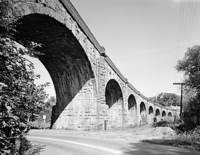
 The Thomas Viaduct, a signature monument of Patapsco Valley State Park | |
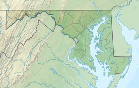
| Location | Anne Arundel County, Baltimore County, Carroll County and Howard County, Maryland, U.S. |
| Nearest city | Baltimore, Maryland, U.S. |
| Coordinates | 39°17′35″N 76°47′12″W / 39.29306°N 76.78667°W[2] |
| Area | 14,270 acres (57.7 km2)[3] |
| Elevation | 374 ft (114 m)[2] |
| Designation | Maryland state park |
| Established | October 6, 1907 |
| Named for | Patapsco Valley |
| Administrator | Maryland Department of Natural Resources |
| Website | Patapsco Valley State Park |
Patapsco Valley State Park /pəˈtæpˌskoʊ/ is a Maryland state park extending along 32 miles (51 km) of the Patapsco River south and west of the city of Baltimore, Maryland.[4] The park encompasses multiple developed areas on over 14,000 acres (5,700 ha) acres of land, making it Maryland's largest state park. In 2006, it was officially celebrated as Maryland's first state park, its first formation being in 1906.[5] Patapsco Valley State Park is managed by the Maryland Department of Natural Resources.
- ^ Cite error: The named reference
IUCN1was invoked but never defined (see the help page). - ^ a b "Patapsco State Park". Geographic Names Information System. United States Geological Survey, United States Department of the Interior.
- ^ Cite error: The named reference
acreagereportwas invoked but never defined (see the help page). - ^ Cite error: The named reference
mdnrwas invoked but never defined (see the help page). - ^ Cite error: The named reference
centennialwas invoked but never defined (see the help page).
