This article needs additional citations for verification. (October 2011) |
| Paterson New South Wales | |||||||||||||||
|---|---|---|---|---|---|---|---|---|---|---|---|---|---|---|---|
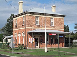
 Paterson Post Office on the corner of Duke and King Streets | |||||||||||||||
| Coordinates | 32°35′S 151°36′E / 32.583°S 151.600°E | ||||||||||||||
| Population | 892 (2016 census)[1] | ||||||||||||||
| • Density | 21.55/km2 (55.80/sq mi) | ||||||||||||||
| Established | 1833 | ||||||||||||||
| Postcode(s) | 2421 | ||||||||||||||
| Elevation | 30 m (98 ft) | ||||||||||||||
| Area | 41.4 km2 (16.0 sq mi)[2] | ||||||||||||||
| Location | |||||||||||||||
| LGA(s) | |||||||||||||||
| County | Durham | ||||||||||||||
| Parish | Houghton | ||||||||||||||
| State electorate(s) | Upper Hunter[3] | ||||||||||||||
| Federal division(s) | Paterson | ||||||||||||||
| |||||||||||||||
| |||||||||||||||
Paterson is a small township in the lower Hunter Region of New South Wales, Australia. Located within Dungog Shire and City of Maitland, it is situated on the Paterson River. It is in the middle of what was once dairy, timber and citrus country and is now more significantly a feeder town for the nearby mining industry in the Upper Hunter and the city of Newcastle. It was named after one of the first known Europeans in the area was Colonel William Paterson in 1801 surveyed the area beside the river.[4]
- ^ Australian Bureau of Statistics (25 October 2007). "Paterson (L) (Urban Centre/Locality)". 2006 Census QuickStats. Retrieved 12 November 2009.
- ^ "Spatial Map Viewer". NSW Spatial Services. Retrieved 16 September 2021.
- ^ "Upper Hunter". New South Wales Electoral Commission. Retrieved 23 November 2019.
- ^ "Paterson, NSW". Aussie Towns. Retrieved 16 October 2020.
