Patnitop | |
|---|---|
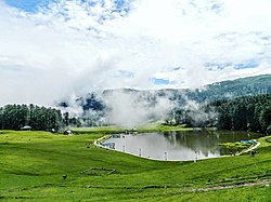
 Sanasar, a small lake in Patnitop in Udhampur district, Jammu and Kashmir, India | |
| Coordinates: 33°5′25″N 75°19′35″E / 33.09028°N 75.32639°E | |
| Country | |
| Union Territory | Jammu and Kashmir |
| District | Udhampur |
| Elevation | 2,024 m (6,640 ft) |
| Languages | |
| • Official | Hindi, Dogri |
| Time zone | UTC+5:30 (IST) |
| PIN | 182142 |
| Website | patnitop |
Patnitop is a hill station, located, between Ramban Town and Udhampur city in the Udhampur district of Jammu and Kashmir, India.[1] It is in located on the Jammu-Srinagar National Highway (which is part of National Highway 44, formerly 1A), 112 km (70 mi) from Jammu, on the way from Udhampur to Srinagar. Situated on a plateau in the Shivalik belt of the Himalayas, Patnitop sits at an altitude of 2,024 m (6,640 ft). The river Chenab flows in close proximity to this location.[2] Patnitop lies in District Udhampur of Jammu And Kashmir
- ^ "Patnitop | Government of Jammu and Kashmir | place of diverse culture, beautiful meadows | India". Retrieved 28 December 2021.
- ^ Silas, Sandeep (2005). "17. Patnitop". Discover India by Rail. Sterling Publishers. p. 47. ISBN 81-207-2939-0.

