Paulding County | |
|---|---|
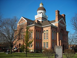
 Courthouse in village of Paulding | |
 Location within the U.S. state of Ohio | |
 Ohio's location within the U.S. | |
| Coordinates: 41°07′N 84°35′W / 41.12°N 84.58°W | |
| Country | |
| State | |
| Founded | March 18, 1839 |
| Named for | John Paulding |
| Seat | Paulding |
| Largest village | Paulding |
| Area | |
• Total | 419 sq mi (1,090 km2) |
| • Land | 416 sq mi (1,080 km2) |
| • Water | 2.4 sq mi (6 km2) 0.6% |
| Population (2020) | |
• Total | 18,806 |
| • Density | 45/sq mi (17/km2) |
| Time zone | UTC−5 (Eastern) |
| • Summer (DST) | UTC−4 (EDT) |
| Congressional district | 5th |
| Website | www |
Paulding County is a county located in the U.S. state of Ohio. As of the 2020 census, the population was about 18,806.[1] Its county seat is Paulding.[2] The county was created in 1820 and later organized in 1839.[3] It is named for John Paulding, one of the captors of Major John André in the American Revolutionary War.[4]
- ^ US Census Bureau. "2020 Population and Housing State Data". Census.gov.
- ^ "Find a County". National Association of Counties. Retrieved June 7, 2011.
- ^ "Ohio: Individual County Chronologies". Ohio Atlas of Historical County Boundaries. The Newberry Library. 2007. Archived from the original on April 6, 2016. Retrieved February 14, 2015.
- ^ Miller, Ray (April 5, 1953). "Paulding Communities Cut Out Of Great Forests". Toledo Blade. pp. 7–3. Retrieved April 30, 2015.

