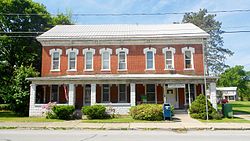
Paxtonville | |
|---|---|
 Post office | |
| Coordinates: 40°46′14″N 77°5′8″W / 40.77056°N 77.08556°W | |
| Country | United States |
| State | Pennsylvania |
| County | Snyder |
| Township | Franklin |
| Area | |
| • Total | 0.88 sq mi (2.27 km2) |
| • Land | 0.87 sq mi (2.26 km2) |
| • Water | 0.00 sq mi (0.01 km2) |
| Population | |
| • Total | 314 |
| • Density | 359.68/sq mi (138.94/km2) |
| Time zone | UTC-5 (Eastern (EST)) |
| • Summer (DST) | UTC-4 (EDT) |
| FIPS code | 42-58536 |
Paxtonville is a census-designated place (CDP) in Franklin Township, Snyder County, Pennsylvania, United States. The population was 314 at the 2020 census.

- ^ "ArcGIS REST Services Directory". United States Census Bureau. Retrieved October 12, 2022.
- ^ "Census Population API". United States Census Bureau. Retrieved October 12, 2022.

