| Peace Arch Border Crossing | |
|---|---|
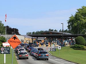
 The Canada Border Inspection Station at the Peace Arch Border Crossing | |
| Location | |
| Country | United States; Canada |
| Location |
|
| Coordinates | 49°00′00.4″N 122°45′15.8″W / 49.000111°N 122.754389°W |
| Details | |
| Opened | 1891 |
| Hours | Open 24 hours |
| Website US Canadian | |
The Peace Arch Border Crossing is the common name for the Blaine–Douglas crossing which connects the cities of Blaine, Washington and Surrey, British Columbia on the Canada–United States border. I-5 on the American side joins BC Highway 99 on the Canadian side. Being the most direct route between the major cities of Seattle, Washington and Vancouver, British Columbia, the crossing is the third-busiest on the border with up to 4,800 cars a day. Trucks and other commercial vehicles are prohibited from this location and use the Pacific Highway Border Crossing, which is 1.6 kilometres (1 mi) eastward.